Waterloo, Belgium
| Waterloo | ||||
|---|---|---|---|---|
.jpg) |
||||
|
||||
 |
||||
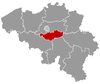
 Waterloo, Belgium
Location in Belgium
|
||||
| Sovereign state | ||||
| Region | ||||
| Community | ||||
| Province | ||||
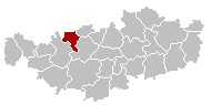
| Arrondissement | Nivelles | |||
| Coordinates | ||||
| Area | 21.03 km² | |||
| Population – Males – Females – Density |
29,315 (2006-01-01) 47.54% 52.46% 1394 inhab./km² |
|||
| Unemployment rate | 10.57% (1 January 2006) | |||
| Mean annual income | €14,866/pers. (2003) | |||
| Mayor | Serge Kubla | |||
| Governing parties | MR | |||
| Postal codes | 1410 | |||
| Area codes | 02 | |||
| Website | www.waterloo.be | |||

Waterloo (in Walloon: Waterlô) (Belgian Dutch pronunciation: [ˈwaːtərloː]) is a Walloon municipality located in the province of Walloon Brabant, Belgium. On December 12, 2009, Waterloo had a total population of 29,573. The total area is 21.03 km² which gives a population density of 1,407 inhabitants per km². Nearly one fifth of the current registered population (5,499 inhabitants) are non-Belgian, many of whom work for institutions or companies in Brussels, the capital of the European Union. These numbers were released by the municipality of Waterloo.
Contents |
Battle of Waterloo
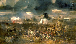
The Battle of Waterloo took place in Waterloo on June 18, 1815 between the First French Empire of Napoleon Bonaparte and the Alliance of the Seventh Coalition (the United Kingdom, Prussia, Austria and others), under the main allied commanders, the Duke of Wellington and General von Blücher.
The strategic location of Waterloo on a paved road towards Brussels explains why the battle took place just south of Waterloo. It was important for the allies to stop Napoleon from reaching Brussels, and Waterloo was the last place to cross before crossing the forest and getting into Brussels.
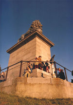
There is a memorial in the form of a statue of a lion (looking towards France) on a hill, with 226 stairs, called La Butte du Lion. Other attractions related to the battle are the Wellington Museum and the Roman Catholic Church of St. Joseph, where Wellington is said to have prayed before going into battle and where British and Dutch plaques commemorating the fallen are now to be seen.
History
The name of Waterloo was mentioned for the first time in 1102 designating a small hamlet at the limit of a big forest (Forest of Soignes) along a major road linking the coal mines area and Brussels. It was a place where travellers and carriers of goods (mainly coal) could rest and escape the bandits at night.
Waterloo was located in the Duchy of Brabant, which was extending in 1477 from Luttre (B) till St Hertogenbosch (NL) with Leuven (B) as the capital city.
A royal chapel was built in 1687 in Petit-Waterloo. This chapel still exists and was extended in 1826 at the back to form today's main church of Waterloo.
Because of the new ideas following the French revolution in 1789, the Austrian Emperor (who was governing present day Belgian territories) wanted to impose reforms. It was followed by a period of unrest that ended with the French invasion in 1794. The old regime (rights of the seigniors, the power of the monasteries, the church keeping official registers) was abolished.
Until 1796, Waterloo was divided into two parts (Grand-Waterloo and Petit-Waterloo) depending, respectively, of the parishes of Braine-l'Alleud (Bishopric of Namur) and of Sint-Genesius-Rode (Bishopric of Mechelen).
A new system based on municipalities was established in 1796. The municipality of Waterloo was created from Petit-Waterloo detached from Sint-Genesius-Rode and 3 former hamlets (Grand-Waterloo, Joli-Bois, Mont-Saint-Jean) detached from Braine-l’Alleud. In 1813, half of the hamlet of Chenois was detached from Braine-l’Alleud and became part of Waterloo. In 1824, Waterloo grew again as the areas Roussart and Sainte-Gertrude from the Forest of Soignes became part of the municipality too. Waterloo had 1571 inhabitants in 1801 and 3202 in 1846.
In 1795, the invaded territories were divided into 9 departments. Some municipalities, including Waterloo, became part of the Dyle department, which became the province of Brabant Méridional in 1815 under the Dutch rule after the defeat of Napoleon. It changed name in 1830 when Belgium became independent and became the province of Brabant for 165 years.
In 1977, the second half of the hamlet of Chenois was detached from Braine-l’Alleud and became part of Waterloo together with a part of the hamlet next to the Lion.
In 1995, the province of Brabant was divided to match the limits of the regions created in 1980 (Wallonia, Brussels, Flanders). The part in which Waterloo is situated became the province of Walloon Brabant.
Railway
The station of Waterloo was inaugurated on the 1st of February 1874 at the same time than the startup of the connection Waterloo to Brussels. The line extension towards the South to Nivelles and Luttre was inaugurated on 1st of June 1874. Luttre was already connected to Charleroi since 1843. Waterloo is a local railway station along the line Charleroi-Sud - Nivelles - Brussels. Unfortunately, the fast intercity trains running between Charleroi-Sud - Brussels - Antwerpen-Centraal do not stop in Waterloo because they stop at the nearby IC station of Braine-l'Alleud.
The L (local) trains Nivelles - Waterloo - Brussels - Zaventem airport - Leuven and Braine-l'Alleud - Waterloo - Etterbeek (East of Brussels) - Aalst stop every hour in Waterloo.
There are currenly big works going on to enlarge the railway line between Nivelles - Waterloo - Linkebeek (South of Brussels) to allow a higher frequency of local and intercity trains.
Modern-day Waterloo
Today, Waterloo is home to the European headquarters of MasterCard International. There are two Carrefour hypermarkets, a Delhaize store, an Ibis Hotel, several BNP Paribas Fortis branches, numerous office parks to the east of the town and two international schools: St. John's International School and the Scandinavian School. As a result Waterloo is a polyglot and multicultural town, the Commune offers services in French, Dutch, and English. A row of shops, called Petit Paris is situated on the Chaussée de Bruxelles (which becomes Chaussée de Waterloo or Waterloosesteenweg when leaving Waterloo in the North and nearing Brussels).
Etymology
The placename, of Dutch origin, is most likely derived from "water" which should be understood in Waterloo not as "water" but as "wet", and from "Lo(o)", an ancient word for "forest" or "clearing in a forest". The early settlement was located on a marshy clearing in the forest of Soignes.
Mound of Waterloo
The mound of Waterloo was erected on the famous battlefield located south of Waterloo.
External links
|
|||||||